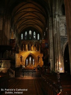
18 May ’05, Wednesday. The Cliffs of Moher
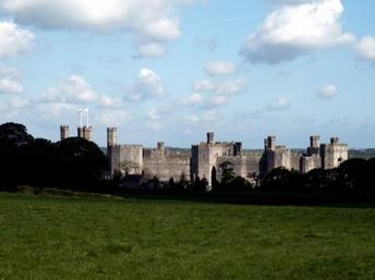
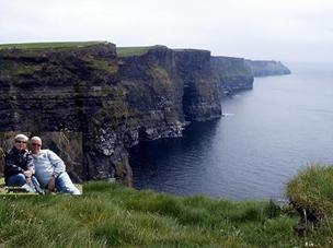
Leaving Dingle, we took the Connor Pass, which took us right into the climb as soon as we left town. The road was as many we have traveled lately, twisting, heaving up and down, and as narrow as could be and still be passable. Fact is, there were times when you have to stop to let on-coming traffic by. One major thing of difference from our drive to Dingle, is that this route was virtually construction free, and the road way was decent enough. Once we got to Tralee, we headed East by Northeast to Limerick, and then a turn West by Northwest to the coast and “The Cliffs of Moher”. The scenery ranged from just plain pasture land with grazing cattle, to pristine tri-colored green fields spotted with sheep, decaying rock homesteads, and signs of a castle or fortress over-grown with vines. Once we arrived at the Cliffs of Moher, we found we weren’t the only visitors to Ireland. I would imagine that in the summer time all the sites will be swarming with tourists, so having 4 bus loads and a dozen or two cars isn’t anything to the vendors. Admittance to the site to see the cliffs was free, but the parking was $4 Euro for the 30-45 minutes we were there. The “Cliffs of Moher” were as advertised and everything that I’ve read…wonderful, don’t miss,… We had a good time !! Following the coast road another 3 or 4 miles and we were in the twin little villages of Doolin. Our campground was right in the middle of the two, and we had a chance to walk them both (that took all of a couple of minutes, excluding lunch and shopping)… Our plans for the night were to go out and have a good time listening to the music and a beer or two, but because we were so early for everything to start, we put in a movie to watch. Well, Mikleane, we just had to watch both CD’s of Pride and Prejudice. All 4 hours of it…yep, too late to go out, and besides, it was really blowing and raining very hard and we would be walking about a mile each way just to get there…I know, I know, “tough it out”… well maybe next time… Tomorrow…North…
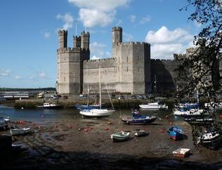
Leaving Dingle, we took the Connor Pass, which took us right into the climb as soon as we left town. The road was as many we have traveled lately, twisting, heaving up and down, and as narrow as could be and still be passable. Fact is, there were times when you have to stop to let on-coming traffic by. One major thing of difference from our drive to Dingle, is that this route was virtually construction free, and the road way was decent enough. Once we got to Tralee, we headed East by Northeast to Limerick, and then a turn West by Northwest to the coast and “The Cliffs of Moher”. The scenery ranged from just plain pasture land with grazing cattle, to pristine tri-colored green fields spotted with sheep, decaying rock homesteads, and signs of a castle or fortress over-grown with vines. Once we arrived at the Cliffs of Moher, we found we weren’t the only visitors to Ireland. I would imagine that in the summer time all the sites will be swarming with tourists, so having 4 bus loads and a dozen or two cars isn’t anything to the vendors. Admittance to the site to see the cliffs was free, but the parking was $4 Euro for the 30-45 minutes we were there. The “Cliffs of Moher” were as advertised and everything that I’ve read…wonderful, don’t miss,… We had a good time !! Following the coast road another 3 or 4 miles and we were in the twin little villages of Doolin. Our campground was right in the middle of the two, and we had a chance to walk them both (that took all of a couple of minutes, excluding lunch and shopping)… Our plans for the night were to go out and have a good time listening to the music and a beer or two, but because we were so early for everything to start, we put in a movie to watch. Well, Mikleane, we just had to watch both CD’s of Pride and Prejudice. All 4 hours of it…yep, too late to go out, and besides, it was really blowing and raining very hard and we would be walking about a mile each way just to get there…I know, I know, “tough it out”… well maybe next time… Tomorrow…North…